 Roadside Attraction Sand Island Petroglyph Panel
Bluff
Overview
|
Thu 78 | 44 |
Fri 80 | 46 |
Sat 80 | 45 |
Sun 72 | 46 |
Mon 70 | 39 |
| View Full Weather Details | ||||
|
Thu 78 | 44 |
Fri 80 | 46 |
Sat 80 | 45 |
Sun 72 | 46 |
Mon 70 | 39 |
| View Full Weather Details | ||||

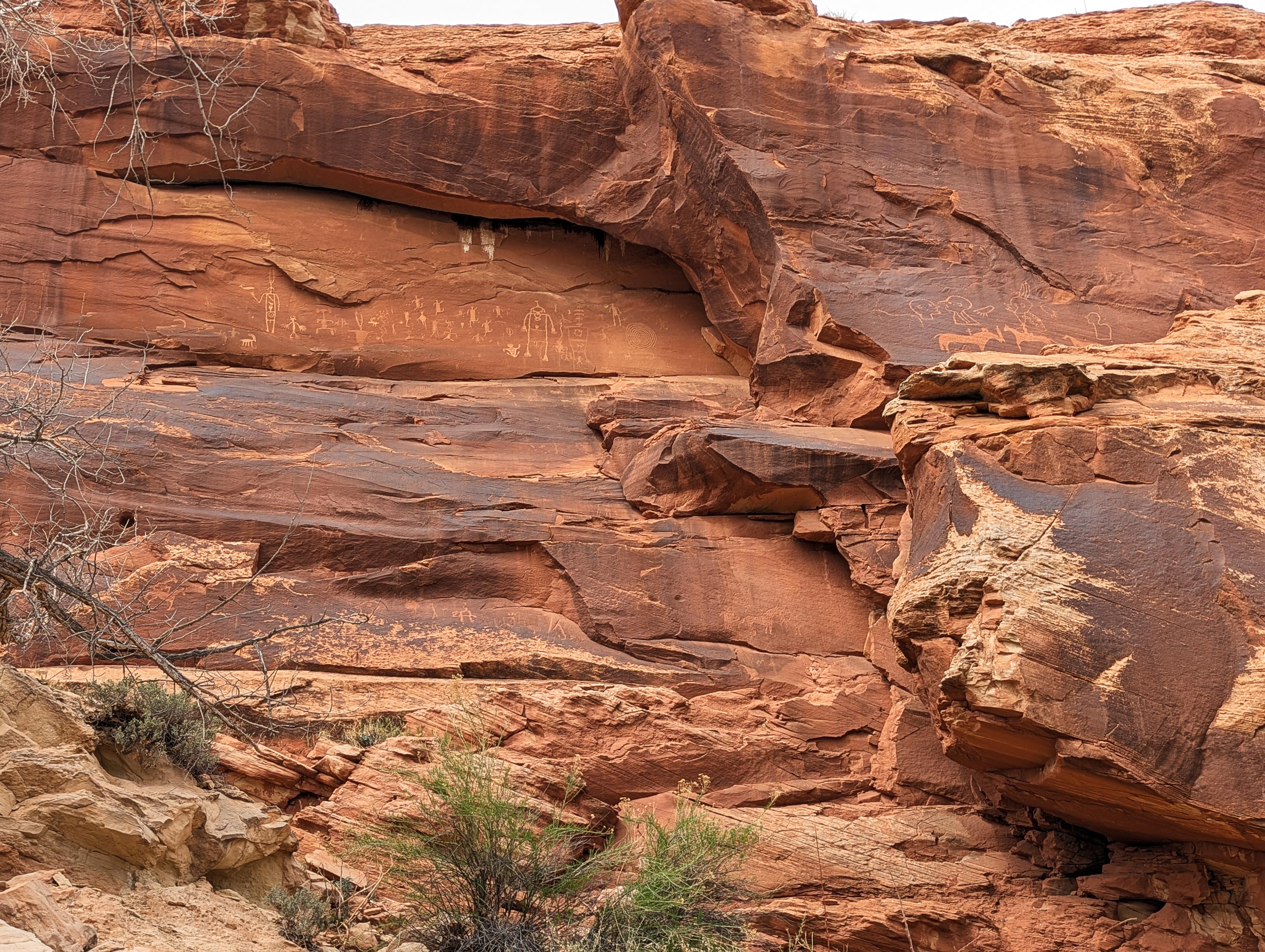
Hundreds of figures
Sand Island Petroglyph Panel is a large panel near Bluff. On the banks of the San Juan River, it is easy to envision this lush area as a gathering place for ancient peoples. The west panel is extensive, with literally hundreds of figures, and dates from the earliest inhabitants of the area through the Pueblo III period. (AD 1150 to 1350) There are a few more modern inscriptions mixed in as well.
A new 1-mile roundtrip trail on the east side of the campground visits several additional rock arts sites. None are as big as the west, but still very interesting panels to visit.
Visiting the panels makes a great side trip when passing by. A BLM campground at the panel and boat launch is available for those doing portions of the San Juan River.
The largest panel along the east trail.
Getting There
Travel west out of Bluff Utah about 3 miles on state highway 191. At mile post 22.1, turn south into the well signed Sand Island Campground. Follow the road down to the campground where it splits. Right goes to the west panel and is signed. Straight goes to the boat ramp, and left goes past the ranger buildings and to a trailhead for the hiking trail.
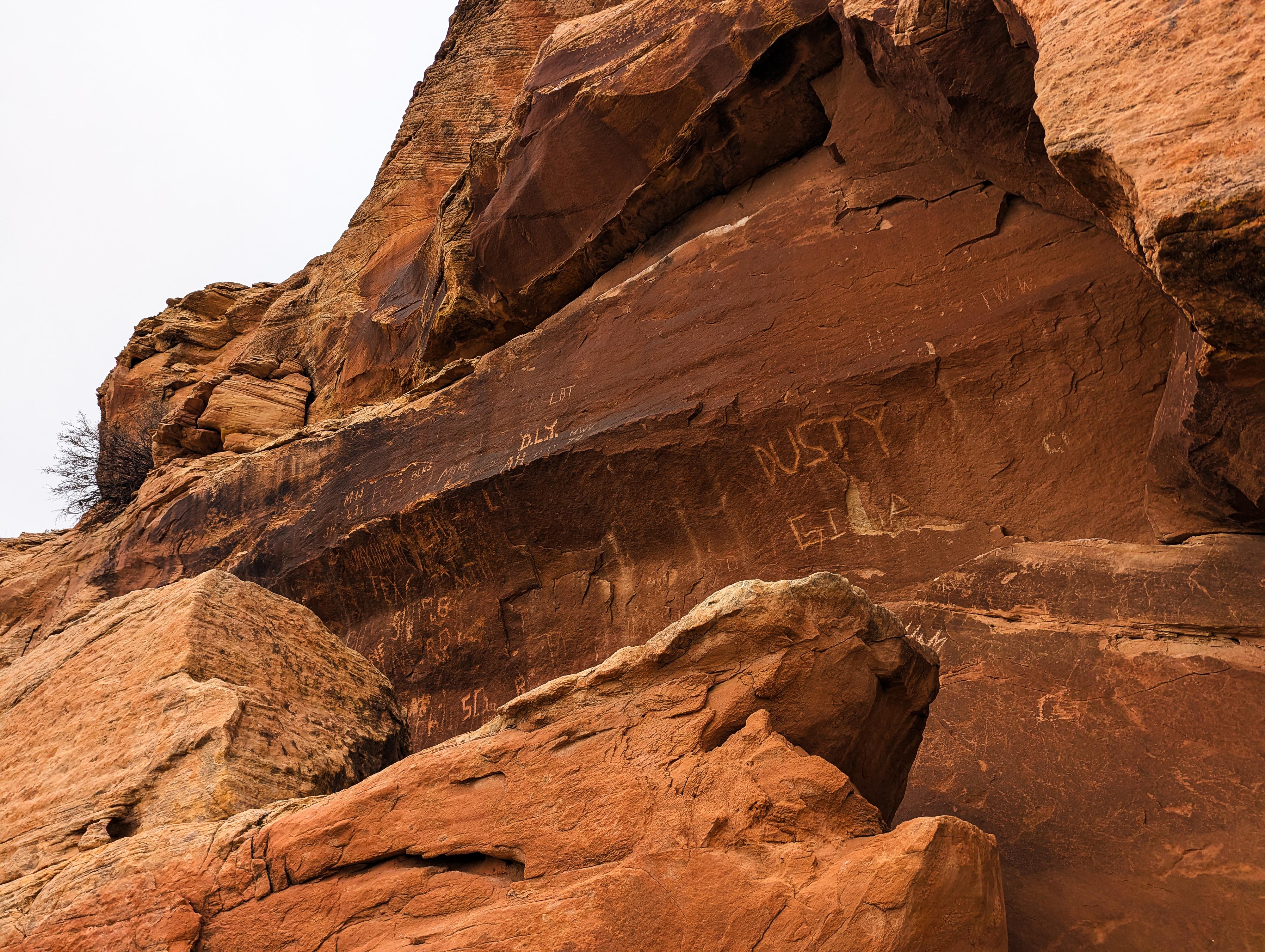
Graffiti near the start of the east side trail
Route
Rock art and historic sites are fragile, non-renewable cultural resources that, once damaged, can never be replaced. To ensure they are protected, please:
- Avoid Touching the Petroglyphs: Look and observe, BUT DO NOT TOUCH!
- Stay on the Trails: Stay on the most used trails when visiting sites, and don't create new trails or trample vegetation.
- Photography and Sketching is Allowed: Do not introduce any foreign substance to enhance the carved and pecked images for photographic or drawing purposes. Altering, defacing, or damaging the petroglyphs is against the law -- even if the damage is unintentional.
- Pets: Keep pets on a leash and clean up after them.
- Artifacts: If you happen to come across sherds (broken pottery) or lithics (flakes of stone tools), leave them where you see them. Once they are moved or removed, a piece of the past is forever lost.
West Panel
For the west panel, it is visible and signed. You drive right to it.
East Panels Trail
A new (circa 2025) trail had been built on the east side of the campground that visits several panels. As of 2025, this looked recently built and perhaps not quite complete.
The trail is wide, gravel, and suitable for almost everyone. From the east side of the campground, follow the trail, keeping an eye on the cliff band alongside the trail. Right near the trailhead, there is quite a bit of graffiti. As you head east along the trail, there are some small, dispersed rock art sites along the cliff, in addition to several larger panels. The larger panels are easy to spot, and it appears they will have interpretive signs put in soon.
In spring 2025, the trail ends at a large panel about 0.5 miles from the trailhead. This is the largest panel of the hike, and though a bit high, very interesting to see.
Continue from the end of the main trail on a social trail a bit further. There are a few more petroglyphs, then a small side canyon comes in on the left with a wooden ladder visible up on its left side.
Just past this side canyon is a small petroglyph panel on the bend. It is difficult to see well since the river comes up against the cliff right below it. This spot also has a nice view of the San Juan River.
Return the same way.
Photos
Maps

| Trailhead |
12S 623341mE 4124917mN N37° 15' 46" W109° 36' 32" |
| West Panel |
12S 622444mE 4124805mN N37° 15' 42" W109° 37' 09" |
| East Panel 1 |
12S 623428mE 4124931mN N37° 15' 46" W109° 36' 29" |
| Small Panel |
12S 623894mE 4125138mN N37° 15' 52" W109° 36' 10" |
| Large Panel Up High |
12S 623915mE 4125138mN N37° 15' 52" W109° 36' 09" |
| Petroglyphs |
12S 623979mE 4125153mN N37° 15' 53" W109° 36' 06" |
| River Panel |
12S 624047mE 4125162mN N37° 15' 53" W109° 36' 04" |