 Hiking Cobb Peak
Silver Island Mountains
Overview
|
Mon 60 | 43 |
Tue 63 | 41 |
Wed 64 | 46 |
Thu 65 | 46 |
Fri 70 | 49 |
| View Full Weather Details | ||||
|
Mon 60 | 43 |
Tue 63 | 41 |
Wed 64 | 46 |
Thu 65 | 46 |
Fri 70 | 49 |
| View Full Weather Details | ||||
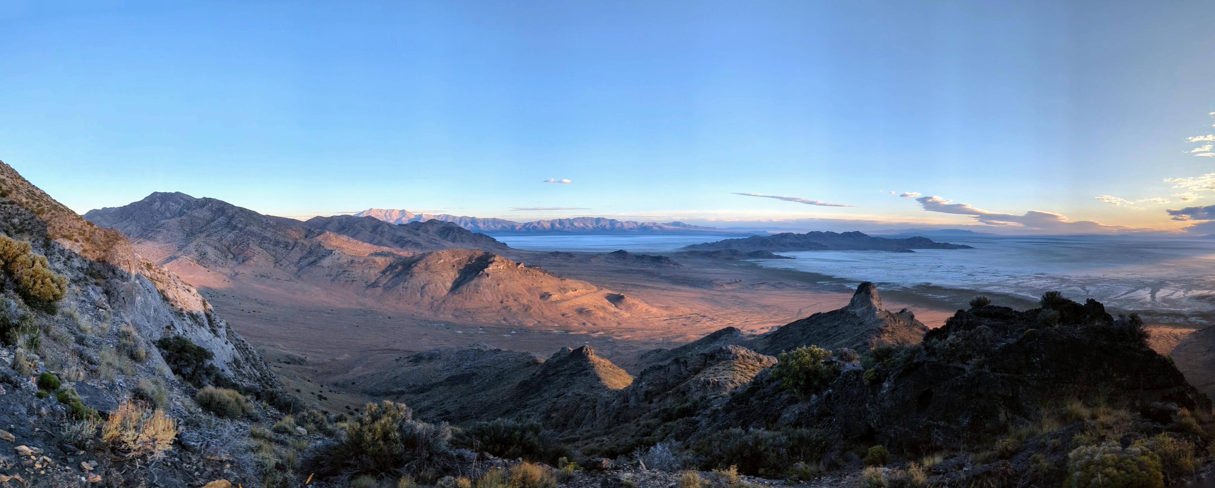
Panorama from about 1/2 way up. Crater Island and the Pilot Range in the distance.
What to say about Cobb Peak? Lovely views for sure, but my least favorite of the half dozen or so peaks I have done in the Silver Island Mountains. At a bit over 3 miles round trip with 2,200 feet of elevation gain to reach the summit, I expected this to be a very steep hike. It is, but it is also very loose and requires a fair bit of route finding. I generally pay close attention on my way up peaks and don't have a problem coming down, but somehow still managed to get cliffed out a couple of times on the return down the peak! Expect much steep, loose limestone and route finding. This is not a route I would recommend for beginners or dogs. Experienced desert peak baggers only!
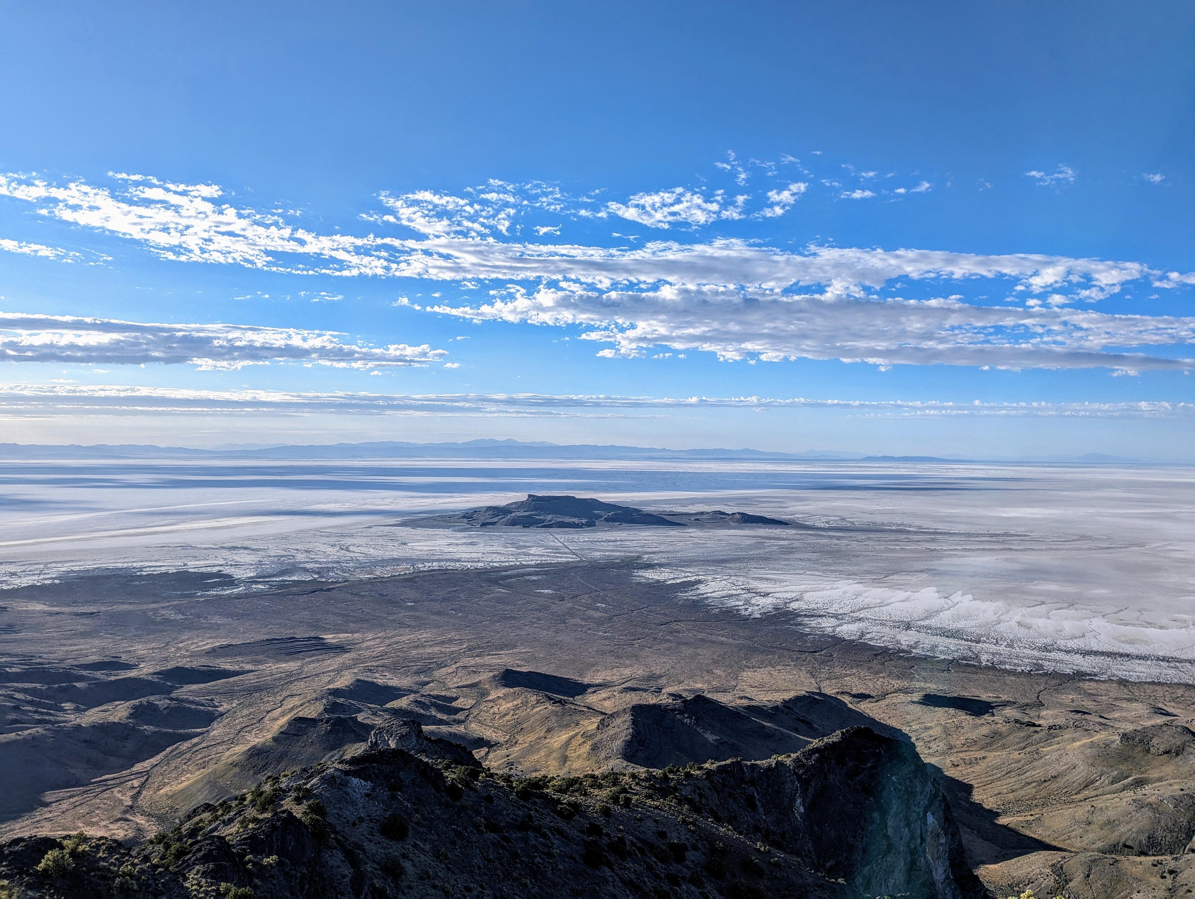
Floating Island in the distance from the summit. A big, vast open view.
Getting There
Reaching Crater Island starts from the northern end of the Silver Island Scenic Byway. To reach the northern end of the scenic byway:
Go north off I-80 at exit 4. The exit is a few miles east of Wendover, UT, and about 115 miles west of Salt Lake City.
Once off the freeway, reset your odometer on the north side of the freeway and head north toward Bonneville Salt Flats.
1.2 miles - left onto a paved road.
1.95 miles - Right onto a dirt road. This is the Silver Island Mountain Byway/Eastside. Stay on this main dirt road as it travels north along the base of the Silver Island range. Ignore minor side roads. After 30.1 miles is a junction with a two-track leaving on the left. This is on the north end of the Silver Island Mountains and a couple of miles before Donner-Reed pass.
Turn onto the two-track road and follow it south for 1.6 miles to where a couple of juniper trees are on the left side of the road and there is a very small pullout. This is the trailhead. On my trip, there was also a large pile of firewood near the trees. If camping in the area, I would look for a spot along the Scenic Byway instead of at the trailhead proper.
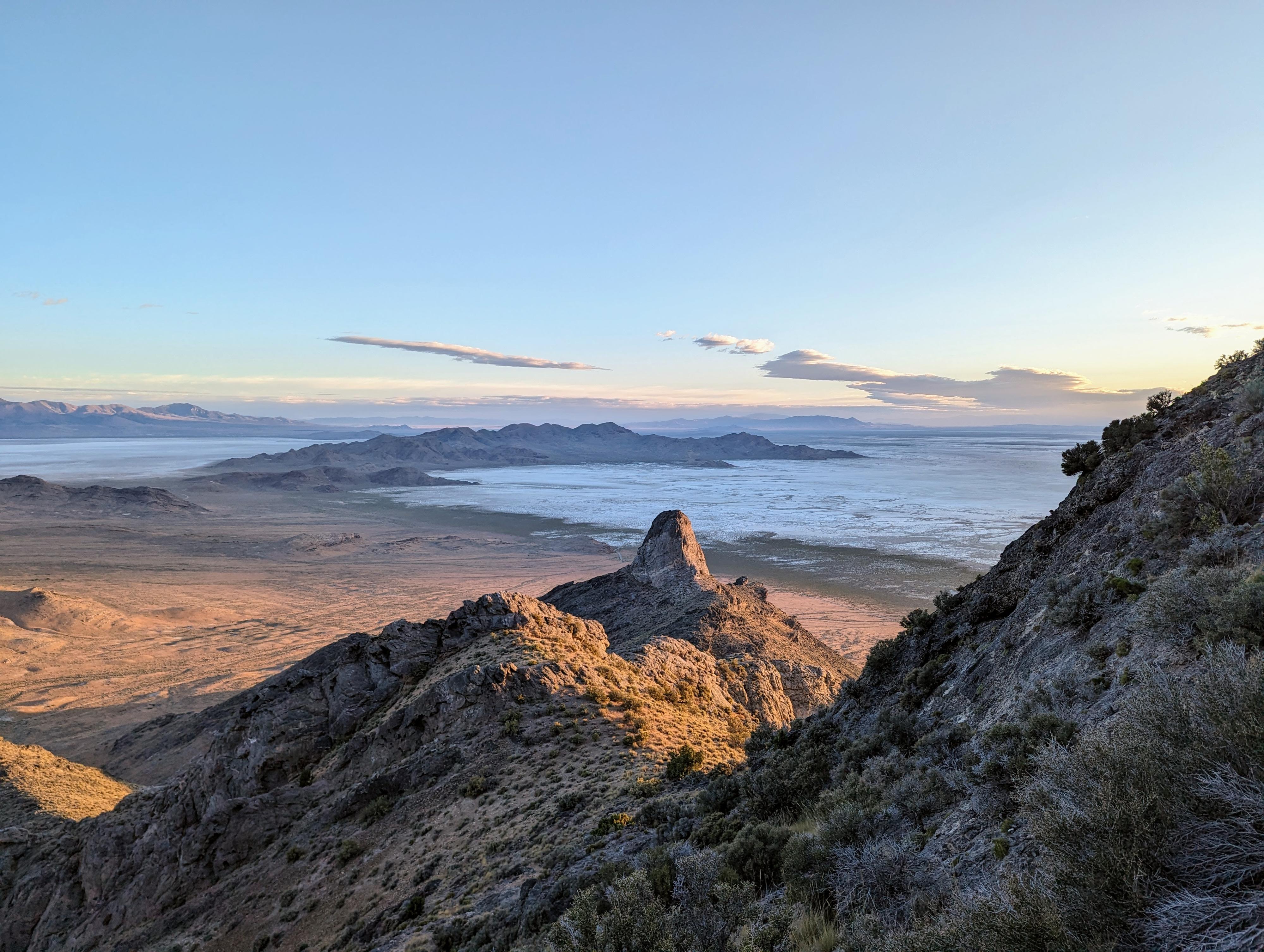
Morning light on the Thumb, with Crater Island in the background.
Route
From the parking spot, see the rock dome that looks like a thumb on the skyline to the northeast? That is a good reference point. The hike doesn't go up the ridge to the thumb, but instead goes up the next ridge south of the thumb. From the parking area, the ridge you want to go up is almost due east. Head for it. There is a large boulder a short distance up that makes a good landmark.
As you work up the ridge, a few rock sections block the path. The first, I went up the right side a short distance, crossed over, then went up the left side. Higher on the ridge is another large rock outcropping, when you are getting close to the same elevation as the Thumb Rock to the north. Go left around this one. Once this high, begin route finding up and a bit right. It is not far to the ridge where you get the first glimpses of the vast flat plains to the east.
You will only be on the ridge briefly, before deviating to the right (south) side of the ridge and working up a steep slope to rejoin the ridge again.
Soon you can see the ridge becomes steep rock. Look for a small "saddle" between the ridge on the left, and a rock outcropping on the right. At the saddle, you can see Cobb Peak high above to the south. You can also see many options here to work up to the summit. From the saddle, I traversed south to a steep, loose, rocky, and small drainage. I followed the drainage up to the ridge proper, then a short ridgeline hike to the summit of Cobb. Phew!
Return the same way, being cautious of loose rock. I found the down quite tedious and probably as hard as going up!
Photos
Maps

| Trailhead |
12T 268897mE 4539284mN N40° 58' 19" W113° 44' 48" |
| Large Outcropping |
12T 269794mE 4538902mN N40° 58' 08" W113° 44' 09" |
| Large Outcropping2 |
12T 270032mE 4538775mN N40° 58' 04" W113° 43' 59" |
| Ridge |
12T 270070mE 4538802mN N40° 58' 05" W113° 43' 57" |
| Saddle |
12T 270138mE 4538450mN N40° 57' 54" W113° 43' 54" |
| Summit Ridge |
12T 270230mE 4538017mN N40° 57' 40" W113° 43' 49" |
| Cobb Peak |
12T 270069mE 4537892mN N40° 57' 35" W113° 43' 56" |