 Hiking Big Horn Canyon
Hole In The Rock
Overview
|
Tue 67 | 36 |
Wed 72 | 40 |
Thu 69 | 44 |
Fri 74 | 44 |
Sat 74 | 44 |
| View Full Weather Details | ||||
|
Tue 67 | 36 |
Wed 72 | 40 |
Thu 69 | 44 |
Fri 74 | 44 |
Sat 74 | 44 |
| View Full Weather Details | ||||
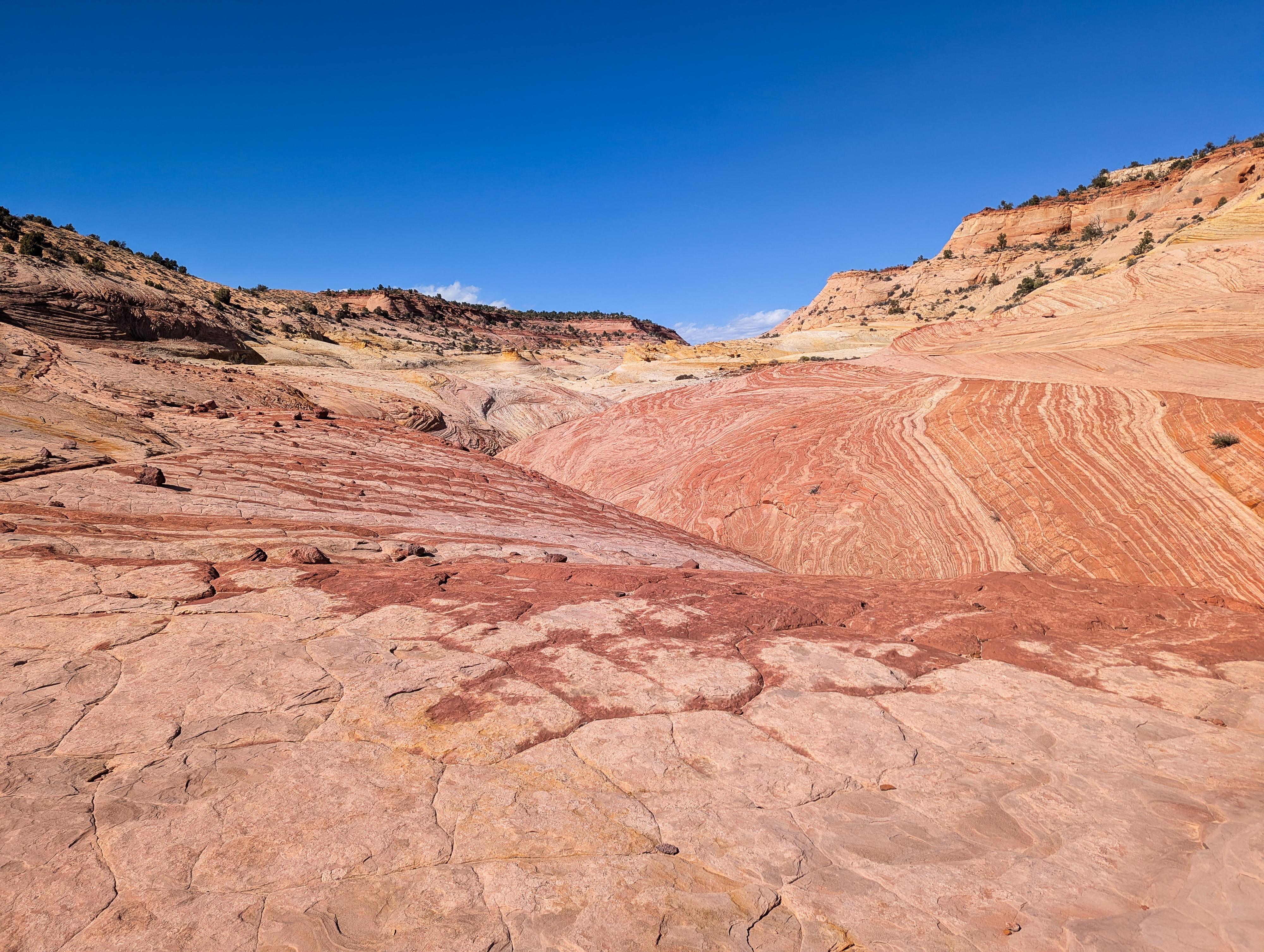
Colorful open slickrock in the lower end of the main fork of Big Horn
One of my first adventures in Escalante back in the 90's was to hike down Big Horn Canyon from the Old Sheffield Road. We made it just about to Harris Wash before returning. At the time, I thought the canyon was pretty, and colorful, but also SO much sand hiking!
Fast-forward a couple of decades, and I finally returned, this time starting from Harris Wash. Though the full Big Horn from Old Sheffield is still a somewhat popular hike, visiting from Harris Wash and going up the West Fork has become quite popular. It is easy to see why. The West Fork of Big Horn is deep, dark, and narrows in spots. It has spectacular colors and textures! I, personally, enjoyed it more than the nearby classic Zebra.
So, you have two options. If you have two cars and don't mind doing the shuttle, this can be done as a one-way hike from the Old Sheffield Road down to Harris Wash. It is a bit over 6 miles and a lovely hike, though the deep sand may make it feel longer than you might expect. You can easily visit the west fork along the way. The second option is an out-and-back from Harris Wash. This doesn't require a car shuttle and still visits some of the best parts of Big Horn. It is shorter, depending on how far up you explore the main fork of Big Horn, but also saves the time and hassle of doing the shuttle. I prefer the out-and-back.
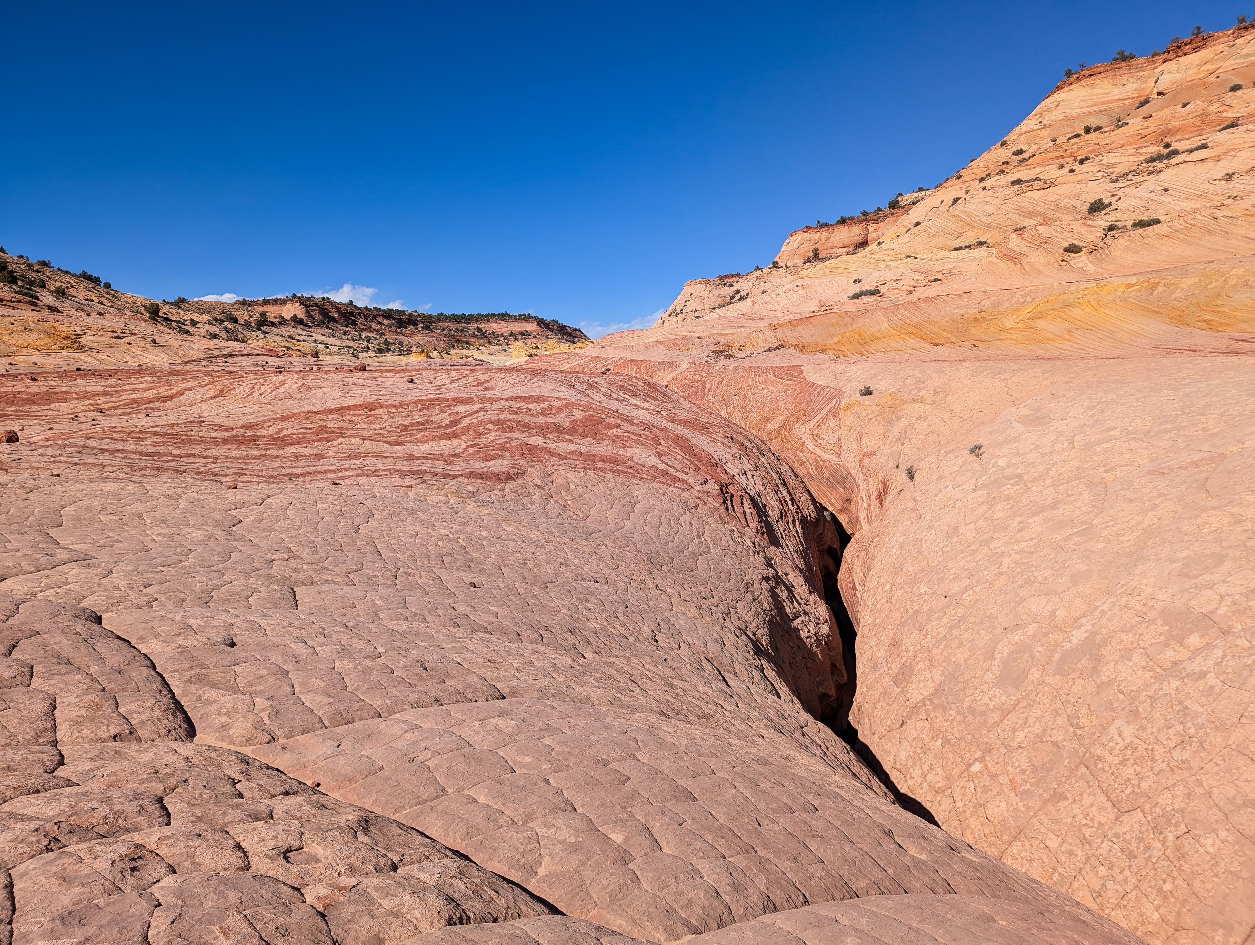
Looking into the main fork narrows from a bench above.
Getting There
Old Sheffield Road Trailhead
Head east out of the town of Escalante about 9.5 miles on highway 12 until you reach mile post 70. The old Sheffield road goes off on the east side of the highway here, right on a bend. Follow the Old Sheffield road for 2.8 miles. There is a parking spot or two here, just after the Old Sheffield road has crossed a small wash that is the upper end of Big Horn. This is the trailhead.
Harris Wash Trailhead
Head east out of the town of Escalante about 5 miles on highway 12 until the well signed Hole in the Rock road on the south side of highway 12. Reset the odometer as you turn onto this road.
- Mile 0 - Hole-In-The-Rock Road Turnoff ( 12S 453167mE 4175716mN / N37° 43' 39" W111° 31' 53" )
- 4.5 miles - Small parking area on the north side of the road. This is the trailhead for West Big Horn/Big Horn Canyon. This is the trailhead. There is also a short road here that goes down to Harris Wash proper. Park along the Hole In The Rock Road, not down at Harris Wash where there is (usually) a no parking sign. ( 12S 457467mE 4170148mN / N37° 40' 39" W111° 28' 56" )
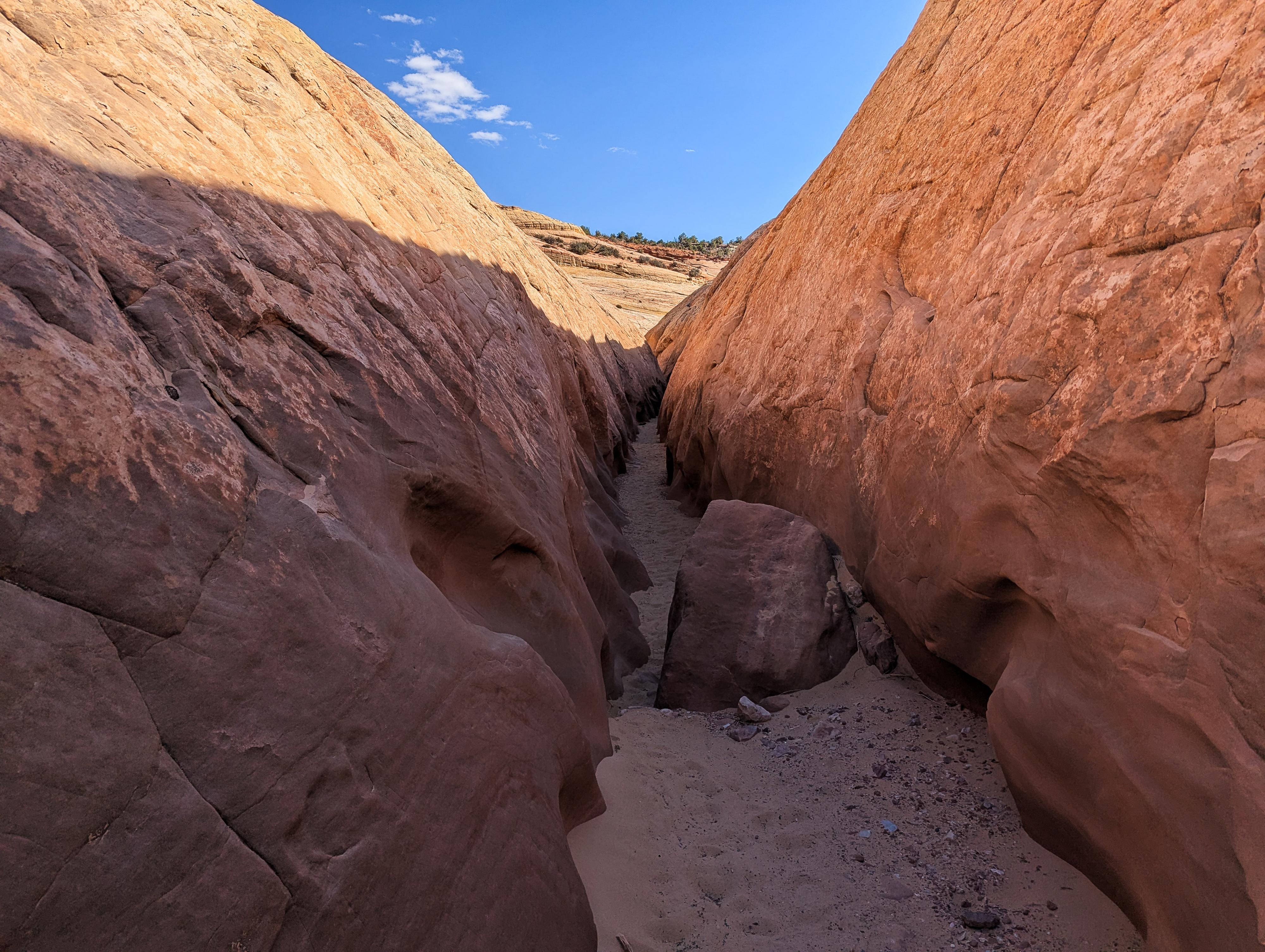
Main Fork Narrows.
Route
From Harris Wash to West Fork (Out-and-back, no shuttle required)
From the trailhead, head down to Harris Wash. The upper section often has a small amount of water flowing down it, but usually with an enthusiastic hop, you can keep your feet dry at all the crossings. There is a mix of cow trails and social trails. Depending on recent floods, the trail may be easy to find and follow (usually) or not much of a trail at all. Either way, amble down. A little over a half mile down is an old corral at a spring. The wash is typically dry below this corral and becomes more colorful and scenic as it enters the Navajo sandstone.
Continue along for about 1.8 miles from the trailhead to where Harris Wash makes a bend to the right with a fence across it. Big Horn comes in on the left here. I thought it was pretty obvious, but do pay attention. Another social trail cuts this corner and continues down Harris Wash, so you could miss Big Horn if you cut this bend.
Once at Big Horn, it is just a few minutes walk up to the junction of the main and west forks. West, to the left, is the one I would recommend starting with, but if you have time, going up the main fork is also recommended. The narrows in the main fork start just above the confluence and go for 3/4 of a mile or so before the canyon opens up more broadly.
West Fork
The west fork starts with a similar character to the narrows in the main fork. They are colorful, with swirling reds and white. Unlike the main fork, the west fork quickly becomes more entrenched. Deeper, darker, and more narrow. It is lovely!
As you head up, a very narrow section with a stuck log presents the first real obstacle. Be careful not to get stuck! If you continue, you will likely need to climb a couple of feet to stem over the narrowest spot, then over the log, or under if you fit! Many groups will choose to stop here.
Just above this first obstacle is a low-angle dry fall. The first move is a bit tricky but easier with a spot, while the rest of the climb is easier. Once above this dry fall, there are no more obstacles until a final dry fall in a room-like area. This is the recommended turn around spot.
From Old Sheffield Road to Harris Wash (One-way hike, shuttle required)
From the trailhead, follow a social trail that heads southwest into the upper reaches of Big Horn Canyon. In less than 1/4 of a mile, the canyon enters the white Navajo sandstone layer in a wide drainage.
Continue down the drainage. The wide, white walls and red cap rock layer are exquisite. As you head down, a dry fall is encountered about 10-15 minutes from the trailhead that is passable on the right.
Continue down a mix of sand and slick rock floored canyon. You may notice the middle fork coming in on the right about 1.6 miles from the trailhead. Not far below this, the canyon narrows a bit with a downclimb or two. This section can be bypassed on the left (looking down canyon) if you would rather not do the downclimbs. Shortly after this section is another short section that starts with an impassable dry fall. A social trail on the right bypasses this obstacle.
The best section, to me, of Big Horn is this final section before its junction with the west fork. The canyon has shallow but very colorful narrows. There aren't any obstacles. It is quite stunning.
Just as the narrows in the main fork open, the west fork comes in on the right (looking down canyon).
After exploring the west fork, continue down a few minute to Harris Wash, and follow Harris Wash upstream about 1.8 miles to the Harris Wash trailhead.
Photos
Maps

| Harris Wash Trailhead |
12S 457450mE 4170160mN N37° 40' 40" W111° 28' 57" |
| Fence |
12S 459962mE 4169710mN N37° 40' 25" W111° 27' 14" |
| West Fork Junction |
12S 459975mE 4169903mN N37° 40' 32" W111° 27' 14" |
| West Fork Dryfall |
12S 459819mE 4170502mN N37° 40' 51" W111° 27' 20" |
| Dryfall |
12S 462165mE 4173732mN N37° 42' 36" W111° 25' 45" |
| Dryfall |
12S 460910mE 4171288mN N37° 41' 17" W111° 26' 36" |
| Old Sheffield Road Trailhead |
12S 462663mE 4174458mN N37° 42' 60" W111° 25' 25" |