
 Kane Creek Rock Art
Moab
Overview
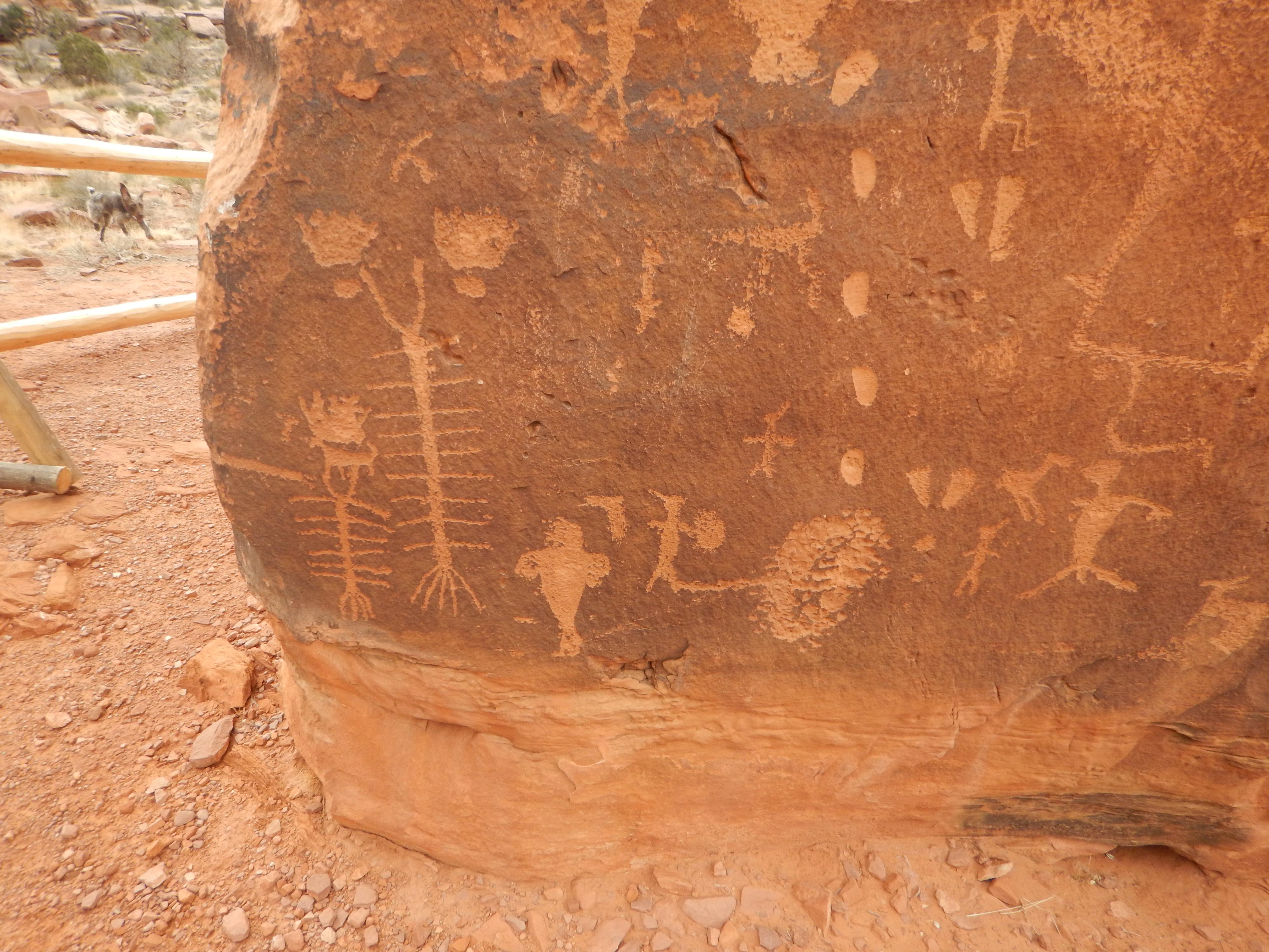
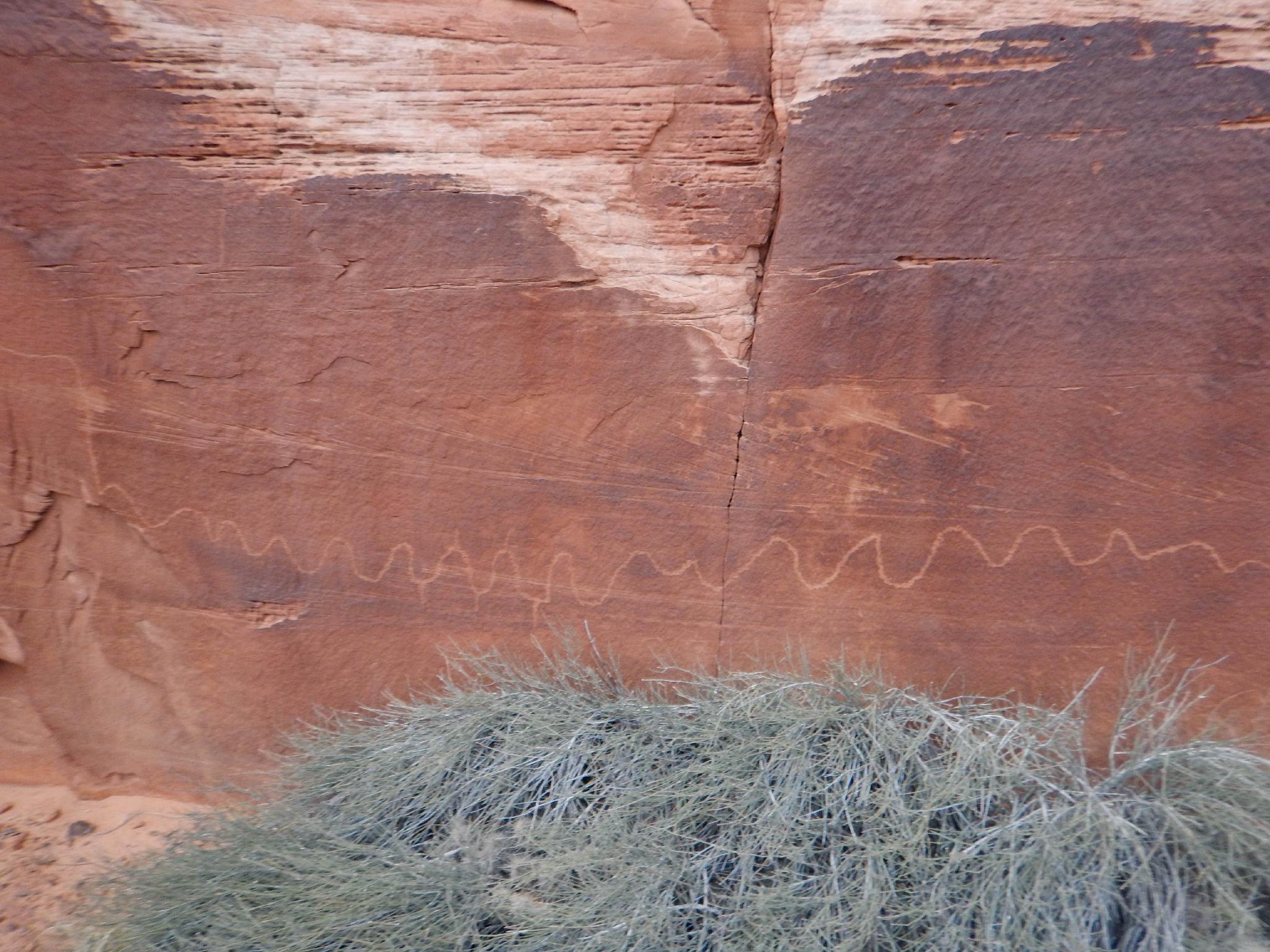
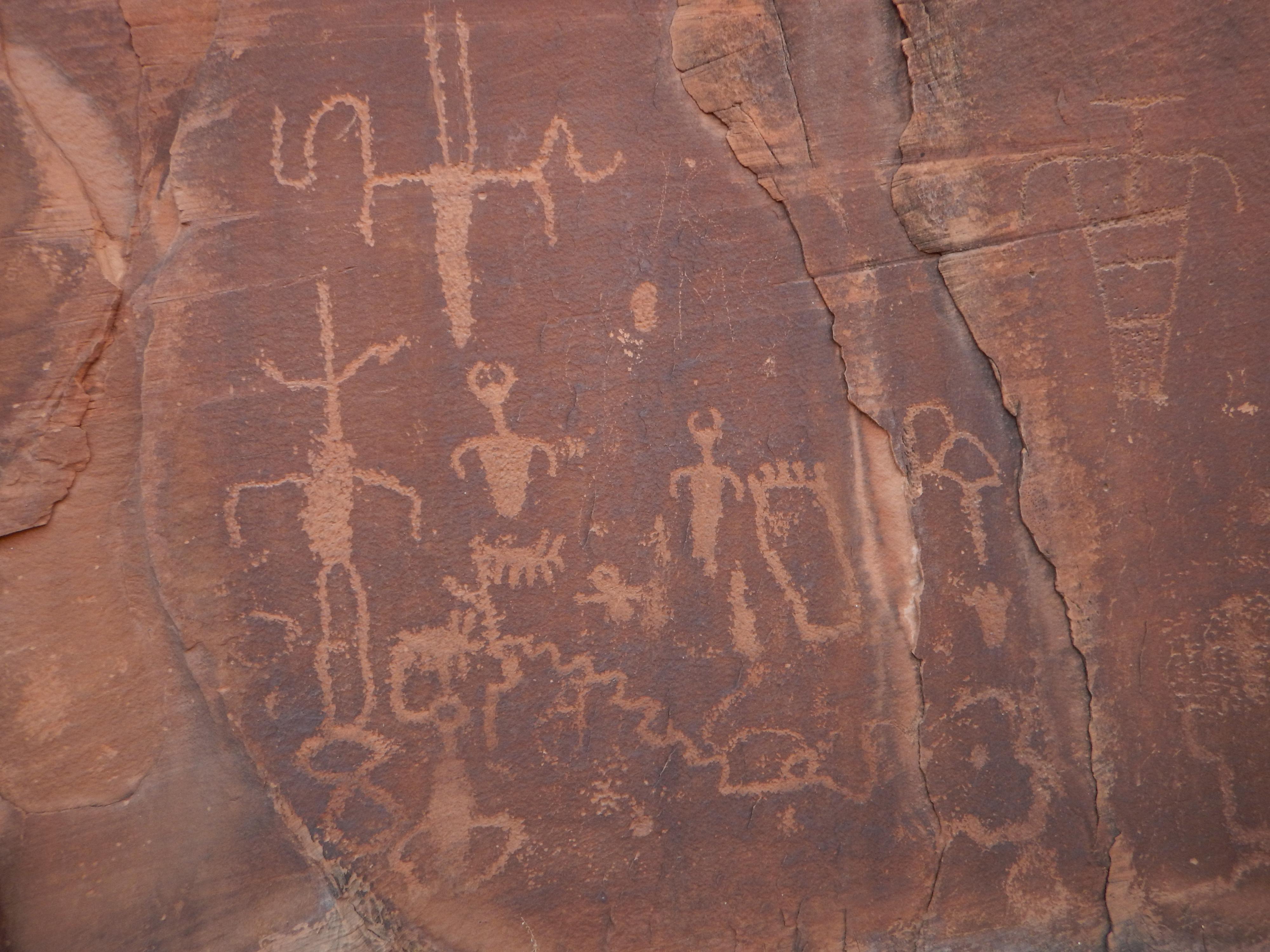
Just a few minutes from downtown Moab, Kane Creek is a gem for those searching for rock art, with a liberal sprinkling of panels throughout the area. Moonflower Canyon Panel, Elephant Panel, Owl Panel, False Kiva, and Birthing Rock are just a few of the very popular and often photographed rock art sites to visit in the canyon. There is much to see and do, plan on at least a half day or even a full day to really enjoy all of the sights.
Much of the rock art in Kane Creek is either visible from the road or a short walk to visit, making this a family-friendly outing that I recommend to all. The road is generally easily passable to most vehicles, though can get muddy at times after recent precipitation.
Getting There
From downtown Moab, head to south to Kane Creek Blvd. Turn right on Kane Creek Blvd. (This is currently where the McDonald's and Burger King are.)
Route Description
Rock art and historic sites are fragile, non-renewable cultural resources that, once damaged, can never be replaced. To ensure they are protected, please:
- Avoid Touching the Petroglyphs: Look and observe, BUT DO NOT TOUCH!
- Stay on the Trails: Stay on the most used trails when visiting sites, and don't create new trails or trample vegetation.
- Photography and Sketching is Allowed: Do not introduce any foreign substance to enhance the carved and pecked images for photographic or drawing purposes. Altering, defacing, or damaging the petroglyphs is against the law -- even if the damage is unintentional.
- Pets: Keep pets on a leash and clean up after them.
- Artifacts: If you happen to come across sherds (broken pottery) or lithics (flakes of stone tools), leave them where you see them. Once they are moved or removed, a piece of the past is forever lost.
Moonflower Canyon
The first stop is Moonflower Canyon. This is a walk-in BLM campground that offers a lot of shade, making it a great summer camping spot. At the entrance to Moonflower Canyon, on the right, is a large panel. Just to the left of the panel is a crack where logs were wedged in years ago to create a slippery ladder up to a viewpoint. The logs are slippery and widely space and the moves a little tricky. Not recommended!
If you have time, wandering up through the campground to the big dryfall at the end of Moonflower is a great 20 minute round trip.
Elephant Panel Trailhead
There isn't much parking here, so besure to park off the highway and to not block any of the private property. The hike follows the dirt road up the hill. Once up the hill, stay left at the junction to continue following the road. The road has a right of way, but much of the land to the west is private.
When the road nears the cliff face, leave the road and follow the cliff face. There are several interesting petroglyph panels here, including the Elephant Panel. If time allows, I recommend following the cliff band all the way to where you can overlook Moonflower Canyon, then following the jeep road back to the trailhead. (2-2.5 miles round trip)
5.1 Mile Panel
The trail climbs up steeply here to the base of the wall. Once at the wall, most of the rock art is to the left, including some very large and impressive panels. As you reach the wall, and turn left. Keep an eye out for an Owl Petroglyph. It is very unique and interesting.
False Kiva Trailhead
From the False Kiva Trailhead, look east. A canyon is just to the right of a cliff point. Though a well-worn trail goes up the canyon bottom, look for a social trail going up the ridge directly to the cliffs. Follow this up to the cliff. Right on the end of the cliff is a False Kiva, and rock art. Follow the cliff band east to visit more panels.
Photos
Maps

12S 623094E 4268231N
38°33'14"N 109°35'14"W
12S 622877E 4268020N
38°33'08"N 109°35'23"W
12S 622649E 4267536N
38°32'52"N 109°35'33"W
12S 622954E 4267607N
38°32'54"N 109°35'20"W
12S 622945E 4267685N
38°32'57"N 109°35'21"W
12S 623075E 4267809N
38°33'01"N 109°35'15"W
12S 622336E 4267009N
38°32'35"N 109°35'46"W
12S 622116E 4266520N
38°32'19"N 109°35'56"W
12S 622500E 4265594N
38°31'49"N 109°35'41"W
12S 622537E 4265618N
38°31'50"N 109°35'39"W
12S 622483E 4265649N
38°31'51"N 109°35'41"W
12S 622429E 4265241N
38°31'38"N 109°35'44"W
12S 621811E 4264636N
38°31'18"N 109°36'10"W
12S 621845E 4264523N
38°31'15"N 109°36'08"W
12S 622635E 4267591N
38°32'54"N 109°35'34"W
12S 622322E 4265360N
38°31'42"N 109°35'48"W
12S 621994E 4264439N
38°31'12"N 109°36'02"W
12S 621899E 4264703N
38°31'21"N 109°36'06"W
12S 622175E 4264674N
38°31'19"N 109°35'55"W